Army Corps Seeks Feedback on Sea Gate Proposal
In September, the U.S. Army Corps of Engineers (USACE) released their New York-New Jersey Harbor and Tributaries Study Draft Integrated Feasibility Report and Tier 1 Environmental Impact Statement outlining several options to further protect New York and New Jersey’s shorelines from flooding, including the bayside of Rockaway. Recently, USACE agreed to extend the public comment period on this massive study to March 7, and they’ve ramped up efforts to get the message out about what the study entails and collect feedback at public meetings. On Tuesday, January 17, they held one of these meetings at Community Board 18 on Bergen Avenue in Brooklyn. In a hybrid-style meeting that was also streamed online, several Rockaway locals attended in person and online to gather information and ask questions.
Col. Matthew W. Luzzatto, commander of the USACE NY District, opened by emphasizing how important it was to gather feedback from the public for this potentially $53 billion project. It was also emphasized that everything in the current draft of the study, including USACE’s tentatively selected Alternative 3B, is preliminary and conceptual, so nothing about the plan is set in stone yet.
The process for this study began all the way back in 2016 and won’t be complete until 2024. After a plan and recommendation from USACE is set, it still must receive congressional approval and funding to be able to move forward. “The number one way to have public feedback is by voting. It is Congress that decides,” Col. Luzzatto said. If that approval and funding is awarded, the plan then enters a pre-construction engineering and design phase, which won’t be complete until 2030, so the earliest people would see construction begin for any of the chosen plans is 2030. For the tentatively selected plan 3B, it wouldn’t be complete until 2044.
Project Manager Bryce W. Wisemiller then gave a rundown of all of the alternatives featured in the study. Alternative 1 would be to take no action and to just allow the current USACE projects underway to serve as the protective measures for the NY/NJ area. Alternative 2 would be constructing a massive underwater storm surge barrier between Sandy Hook, NJ and Breezy Point, making it the longest barrier in the world. This option would also come at the highest cost at $112 billion and would take the longest to create, at 32 years, so it wouldn’t be complete until around 2062. Alternative 3A would include a storm surge barrier near the Throgs Neck Bridge, the Verrazzano and from south Brooklyn to Queens, encompassing Jamaica Bay, plus many shoreline-based measures. This plan would have the largest flooding mitigation measures but also comes at a high cost of $77 billion and would take 24 years to construct. Alternative 4 would create a storm surge barrier in Jamaica Bay and by the Hackensack River, and on individual creeks around Brooklyn and Queens. This alternative would protect a smaller area, would cost $43 billion and would take 14 years to construct. Alternative 5 would be to have no water structures and only have shoreline-based measures in New Jersey and Manhattan. This would come at a cost of $16 billion and would take five years.
USACE’s tentatively selected plan is Alternative 3B. “Evaluations point to the best solution as Alternative 3B. Some features can be implemented quicker, and some will require more time,” Wisemiller said. Alternative 3B comprises of eight large components, including storm surge barriers on smaller creeks like Gowanus, Newtown and Flushing, at the mouth of the Arthur Kill and Kill Van Kull tidal straits in Staten Island, and across Jamaica Bay, along with several shore based measures. This project would cost $52.7 Billion and would take 14 years to complete. “3B is the most economically feasible. It has the greatest net benefits,” Wisemiller explained.
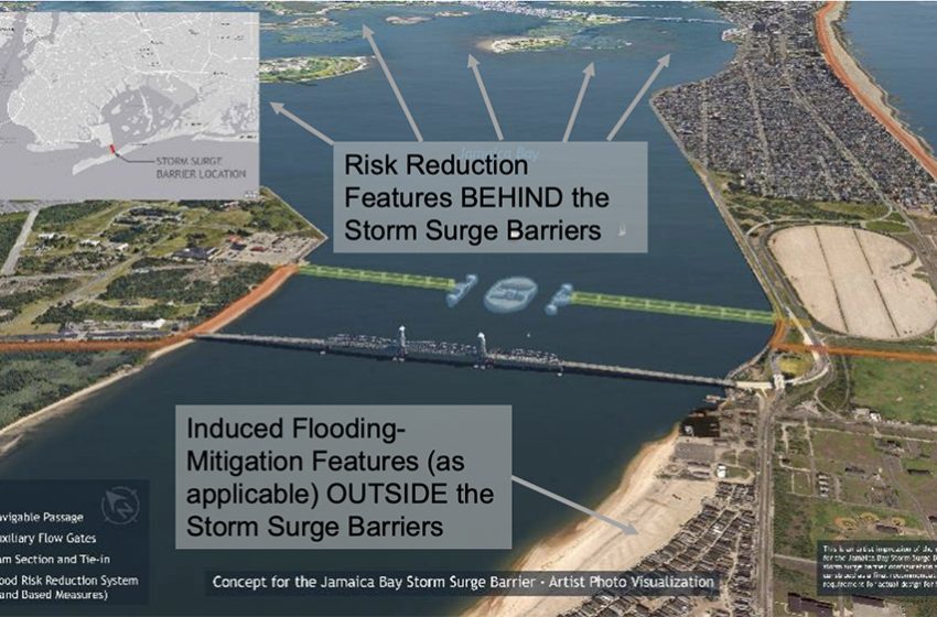
One of the biggest components of 3B in relation to the Rockaway peninsula would be the storm surge barrier, or sea gate, running across Jamaica Bay, from Rockaway to Brooklyn. In renderings, USACE has this structure running parallel to the Marine Parkway Bridge, on the east side of the bridge. Wisemiller explained that the sea gates in the plan, would be shut closed when a storm is expected to bring a seven-foot elevation of water. However, the water being closed off from the eastern portion of Jamaica Bay could have some effects on other areas. “When the gates are shut, there’s induced flooding, making flooding somewhere else worse. It appears Breezy Point is such an area,” Wisemiller said. To respond to potentially worse flooding in Breezy, USACE has factored in shore-based measures into 3B. In USACE’s proposal, this would mean a reinforced dune feature, much like the one currently being built along Rockaway Beach but starting to the west of the Marine Parkway Bridge on the bayside of Roxbury and Breezy, and wrapping all around the tip of the peninsula, and across Breezy and Riis Park, meeting with the current dune ending at Beach 149th Street.
This aspect brought up several questions and concerns from people in the audience and online. Some asked why the Jamaica Bay gate would be placed behind the Marine Parkway Bridge and how this would impact marine traffic. Wisemiller emphasized again that the chosen location for the storm surge barrier is preliminary, but they chose that location so the gate would be in line with the footing of the bridge, which would create the lowest environmental impact. Asked if the gate could be moved further west, so Breezy is included, Wisemiller said, “We could. That’s something to be evaluated further in the study. There are alignments which would stretch from Breezy to Manhattan Beach, but we have incorporated flood mitigation measures for Breezy, and so even with some added cost of these features, this alternative has the greatest net benefit. We don’t want to have any feature that benefits some at the expense of others. The benefit of having it near the bridge is it’s a much shorter distance than from Breezy to Manhattan Beach. The shorter distance and shallow water make for a much cheaper approach, even with more shoreline based measures. More evaluation has to be done but we think this current alignment maximizes benefits.”
Another caveat of this plan in Alternative 3B, is that the National Park Service (NPS) and the Department of Interior (DOI) have to come to an agreement with USACE, since the reinforced dune would cross through NPS areas from Breezy to Riis Park. “This can’t advance without that acceptability. We’ve done some coordination with NPS and we’re looking to advance, but only if those agencies reach an agreement on these features, can they be advanced,” Wisemiller said. An audience member chimed in essentially saying, “NPS should not have the final say in the plan that’s chosen.” USACE agreed but said it’s part of the process and they are currently having conversations with the agencies and all comments from NPS would be part of the record when the next draft for the study is released.
As the meeting ended, Wisemiller reminded the audience that there will be many more public input meetings held while the public comment period is ongoing. Some are set up by USACE directly, but any organization is welcome to invite them to set up a meeting to make the presentation and take public feedback. If interested, email them at:
nynjharbor.tribstudy@usace.army.mil
Public comments can also be sent directly to that email. The full study can be found on the USACE website at: www.nan.usace.army.mil/nynjhats
A story map that shows how each feature of the plan will impact your area, can be found at: https://hats-cenan.hub.arcgis.com/